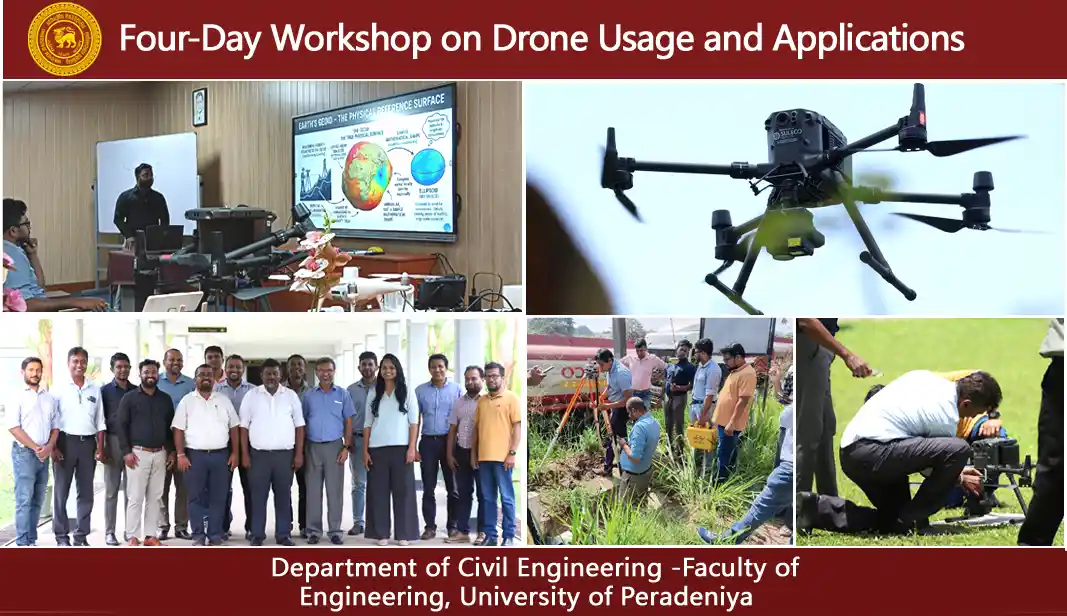
Four-Day Workshop on Drone Usage and Applications
- Date April 23, 2026
- Categories News
Workshop on UAV Aerial Surveying and Data Processing
The Workshop on UAV Aerial Surveying and Data Processing was effectively executed from April 6th to April 9th, 2026, targeting the technical and academic personnel of the Department of Civil Engineering within the Faculty of Engineering at the University of Peradeniya. The primary objective of the workshop was to augment the participants’ theoretical understanding and practical competencies in the increasingly evolving domain of UAV-assisted surveying, mapping, and geospatial data processing. The facilitator for this initiative was Mr. Diluk Premarathna, an independent drone specialist possessing a wealth of industry experience in aerial surveying and UAV applications.
The workshop commenced with an exploration of the Fundamentals of UAV Aerial Surveying, which comprised both theoretical presentations and hands-on practical sessions in the field. Participants were familiarized with the essential principles underlying aerial surveying and its diverse applications across various sectors such as mapping, agriculture, construction, and environmental monitoring. The sessions also elucidated the technological advancements in aerial surveying, emphasizing the transition from traditional manned aircraft and satellite systems to contemporary UAV platforms. Various UAV types, inclusive of fixed-wing and multirotor drones, were examined with a focus on their respective advantages, limitations, and suitable applications. Moreover, participants were acquainted with the foundational concepts of photogrammetry and the significance of image-based measurements in the generation of maps and three-dimensional models.
The subsequent segment of the workshop concentrated on Flight Planning and Data Acquisition. Critical elements, including the procurement of approvals for UAV operations, compliance with regulatory frameworks, airspace constraints, and operator obligations, were thoroughly examined. Participants acquired knowledge regarding mission planning principles, which encompassed the establishment of flight altitudes, image overlap, velocity, and coverage to attain necessary survey precision and safety. Practical sessions were conducted to facilitate UAV configuration, calibration, pre-flight checklist execution, and test flights. Additional training encompassed survey design, coordinate systems, Ground Control Points (GCPs), and RTK/PPK workflows aimed at achieving precise georeferencing. Participants also engaged in practical experiences involving the establishment of base stations, placement of GCPs, delineation of survey boundaries, and execution of autonomous UAV flight missions to capture RGB and multispectral datasets.
Another significant facet of the workshop entailed Data Processing utilizing DJI Terra and Pix4D, wherein participants were acquainted with professional-grade photogrammetry software instrumental in converting raw UAV imagery into actionable spatial products. The training encompassed the processes of importing aerial imagery, generating point clouds, orthomosaics, multispectral outputs, digital elevation models, and three-dimensional models. Methodologies for accuracy assessment and error rectification procedures were also demonstrated. During the laboratory sessions, participants processed the acquired survey data utilizing both software platforms and conducted comparative analyses of the outputs.
The concluding sessions focused on the integration and applications of Geographic Information Systems (GIS), wherein attendees were familiarized with the significance of GIS in spatial analysis and cartography. The discussion encompassed prevalent spatial data formats including Shapefiles, GeoTIFF, KML, and KMZ, alongside the utilization of ArcGIS and QGIS software for the purposes of visualization, analysis, and map generation. Outputs derived from Unmanned Aerial Vehicles (UAVs), such as orthomosaics, Digital Elevation Models (DEMs), contour maps, NDVI maps, and three-dimensional models, were incorporated into GIS platforms for practical utilization. Pertinent case studies across sectors such as agriculture, construction, disaster response, and environmental surveillance were also showcased.
In summary, the workshop offered a significant blend of theoretical frameworks, hands-on field training, software-driven data processing, and GIS-related applications. It proved to be exceedingly advantageous for the technical and academic personnel of the Department of Civil Engineering, empowering them to enhance their proficiencies in contemporary UAV surveying techniques and their engineering implications.